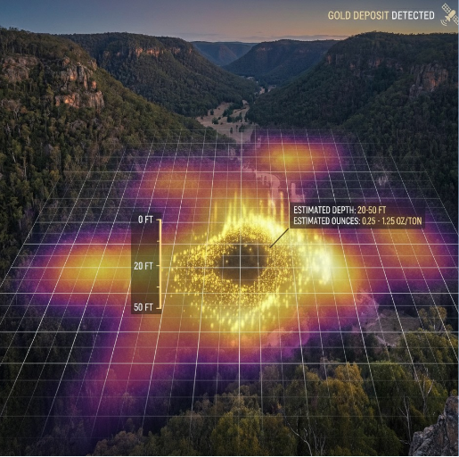
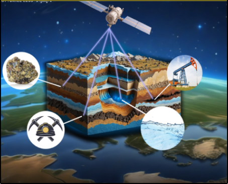
SEE DEEPER. KNOW SOONER. ACT SMARTER.
Our satellite-based subsurface mapping technology enables the remote detection of any element on the periodic table across land and ocean environments with 93% or greater accuracy. Using advanced orbital sensing and AI-driven analysis, we deliver detailed subsurface intelligence without drilling, seismic surveys, or ground disruption—providing a completely non-invasive approach to exploration.
The platform can identify mineral deposits up to 5,000 feet below the surface and oil and gas reservoirs down to 18,000 feet deep, helping organizations uncover previously missed resources and validate exploration targets faster and more efficiently. By eliminating traditional exploration barriers, we dramatically reduce cost, risk, and time-to-decision.
With zero environmental impact, this technology accelerates exploration while supporting sustainability goals. From mining and energy to government and environmental applications, our solution offers a smarter, faster, and more responsible way to see what lies beneath the surface.
DETECTION CAPABILITIES
Comprehensive subsurface analysis across multiple industries and applications,
providing unprecedented insight into Earth's hidden resources.

HYDROCARBON DETECTION
Locate oil and gas deposits without drilling or seismic surveys
Up to 18,000 feet
PRECIOUS METALS
Detect gold, silver, platinum, and rare earth elements
Up to 5,000 feet
BASE METALS & MATERIALS
Identify copper, lithium, iron ore, and industrial minerals
Up to 5,000 feet
UNDERGROUND VOIDS
Detect caves, tunnels, and archaeological sites
Up to 5,000 feet
WATER RESOURCES
Locate underground aquifers and water tables
Up to 3,000 feet
ENVIRONMENTAL MONITORING
Track contamination and environmental changes
Up to 1,000 feet
INDUSTRY APPLICATIONS
Oil & Gas Exploration Energy
Revolutionary approach to hydrocarbon exploration
without environmental disruption
18,000 feet
Detection Depth
93%
Accuracy Rate
Key Benefits:
- No seismic surveys required
- Zero environmental impact
- Faster exploration timelines
- Reduced exploration costs by 60%
Case Study:
Identified major oil reserve in Texas, saving $15M in traditional exploration costs
Survey Process:
- 1 Satellite positioning and target area mapping
- 2 AMRT signal transmission and data collection
- 3 AI-powered analysis and mineral identification
- 4 Detailed report with depth and location data
Mining Exploration Mining
Precision mineral detection for sustainable mining operations
5,000 feet
Detection Depth
93%
Accuracy Rate
Key Benefits:
- Precise deposit mapping
- Minimize environmental impact
- Optimize drilling programs
- Reduce exploration risk
Case Study:
Located gold deposits in Nevada with 95% accuracy, confirmed by subsequent drilling
Survey Process:
- 1 Satellite positioning and target area mapping
- 2 AMRT signal transmission and data collection
- 3 AI-powered analysis and mineral identification
- 4 Detailed report with depth and location data
Archaeological Discovery Research
Non-invasive archaeological surveying for historical
preservation
500 feet
Detection Depth
95%
Accuracy Rate
Key Benefits:
- Preserve site integrity
- Map underground structures
- Identify artifact locations
- Historical documentation
Case Study:
Featured on History Channel's Lost Gold of World War II' - located Yamashita's treasure sites
Survey Process:
- 1 Satellite positioning and target area mapping
- 2 AMRT signal transmission and data collection
- 3 AI-powered analysis and mineral identification
- 4 Detailed report with depth and location data
Water Resource Management Agriculture
Sustainable water resource identification and management
3,000 feet
Detection Depth
90%
Accuracy Rate
Key Benefits:
- Locate underground aquifers
- Optimize well placement
- Water table monitoring
- Drought planning
Case Study:
Helped California farms identify new water sources during drought conditions
Survey Process:
- 1 Satellite positioning and target area mapping
- 2 AMRT signal transmission and data collection
- 3 AI-powered analysis and mineral identification
- 4 Detailed report with depth and location data
CASE STUDIES

OUR FAQ
How long does it take to get a report back?


Typical turnaround time is between 25 to 40 days, depending on project size and complexity.
How does your detection system operate?
Our proprietary Atomic Mineral Resonance Tomography (AMRT) uses a global satellite array to detect unique atomic resonance frequencies of subsurface minerals and hydrocarbons. This non-invasive technology enables high-resolution mapping up to 18,000 feet deep with verified accuracy exceeding 93%, eliminating the need for drilling or seismic surveys.
Which underground resources are detectable?
We detect oil, natural gas, gold, silver, copper, lithium, rare earth elements, water aquifers, geological voids, and other subsurface assets. Our technology is validated for mineral, hydrocarbon, environmental, and archaeological applications.
What is the accuracy of your results?
AMRT surveys consistently achieve verified accuracy of 93% or higher, confirmed through third-party validation and direct drilling comparisons.
What is the scanning process?
You provide a polygon of the target area. We position our five satellites accordingly. Each satellite revisits the location every 108 minutes. Typically, 5–11 passes are sufficient to scan up to 5,000 feet for mineral detection.
How does the satellite work?
Each element has a unique atomic resonance signature. Our satellites passively detect these signatures over multiple passes to isolate and map subsurface deposits. This process produces no false positives.
Can you determine deposit grade?
We cannot determine grade, but we identify location, width, density, and relative concentration. This allows clients to drill directly off our data with minimal additional testing.
What depth can your technology reach?
AMRT penetrates up to 18,000 feet below the surface, including through bedrock, mountains, water, ice, snow, and vegetation.
Does your method impact the environment?
No. Our technology is entirely non-invasive and has zero environmental impact, making it ideal for sensitive or protected areas.
Do you have case studies?
Yes. Case studies covering new discoveries and existing fields are available on our website.
Are permits or licenses required?
No permits or licenses are required. Our technology can scan any land or ocean area globally without land ownership.
Can AMRT scan through ocean, water, ground, rocks, bedrock, trees, snow, ice & iron?
Yes.
GET IN TOUCH
Survey Request Form
What to Expect
- 1 Satellite positioning and target area mapping
- 2 AMRT signal transmission and data collection
- 3 Quantum Algorithim-Powered analysis and mineral identification
- 4 Detailed report with depth and location data
Survey Deliverables
- High-resolution subsurface maps
- Mineral composition analysis
- Depth and location coordinates
- Recommended exploration points
- Technical consultation support
Pricing & Timeline
- Survey Duration: 7-14 days
- Report Delivery: 25-40 days
- Pricing: Custom quote